- Jobling Planning +Environment Ltd
- Belfast 028 9590 4942 | Larne 028 2844 0206
BallynabweeQuarry
Proposed Sand and Gravel Extraction
WELCOME
Welcome to the Online Community Consultation for P Woods & Son. This Consultation relates to a propsal to develop a new proposed sand and gravel pit close tothe exisitng P Woods & Sons Facility at 38a Moyagh Road, Donemana, Strabane. We are consulting with the local community to obtain initial views on this proposed development to help inform the design process prior to the submission of the planning application later this year.
ConsuLtation Details
This Consultation can either be viewed online (from 3rd October to 30th October 2024) or in person on 3rd October, at the venue detailed below:
Venue: Dennett Interchange, 1 Brook Road, Donemana, BT82 0PF
Date: Thursday 3rd October 2024
Time: Drop in anytime between 4 – 7pm
Please take some time to browse the information about the proposal included below and please provide us with your thoughts via the Feedback Form below.
ABOUT OUR PROPOSAL
SITE LOCATION
The proposal relates to the lands located opposite and immediately south of Mountcastle Cemetery in the townland of Ballynabwee, north of Donemana, assillustrated below:.
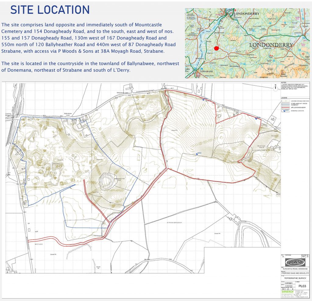
The exact address is: lands located opposite and immediately south of Mountcastle Cemeteryand 154 Donagheady Road, and to the south, east and west of nos. 155 and 157 Donagheady Road, 130m west of 167 Donagheady Road and 550m north of 120 Ballyheather Road and 440m west of 87 Donagheady Road Strabane, with access via P Woods & Son at 38a Moyagh Road, Strabane.
Site Description
This site comprises approximately 19 hectares of farmland. This is mainly comprised to agricultural grassland land that is currently used for grazing. Part of the site includes existing laneways that connect the applicant’s farmland to their existing mineral and recycling operations “P Woods and Sons”. It also links to the neighbouring quarrying operations of “Chambers Sand and Gravel”. This is illustrated in the site layout drawings included further below.
The development site comprises a steeply sloping agricultural field that falls in a southerly direction from Donaheady Road/ Duncastle Road, towards the flatter lands of the south. The site is composed of semi-improved grassland with native species hedgerows around the northern, eastern and western boundaries.
The site is located within the rural area northwest of Donemanagh (Donemana) and immediately west of the small settlement of Donaheady. It is situated within the ‘North Sperrin Hills and Valleys’ Regional Landscape Character Area, which describes the wider landscape as a complex series of hills, plateaux and valleys, which comprises more intricate valleys around Claudy and Dunnamangh. The characteristics of this rural area included farmland and sand and gravel / mineral workings.
The site is not located within any environmental designations or areas of constraint and there are no protected species within the site of the immediate context, as illustrated in the image below.
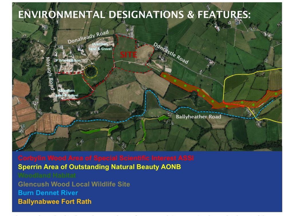
The context comprises a mosaic of agricultural farmland interspersed with mineral workings and clusters of rural development.
Environmentally sensitive features in the wider area, beyond the site area includes; Ballynabwee Fort Rath is located to the southwest of the site, between the site and the applicants existing operations; Burndennett River, which is located over 350m to the south and is a tributary of the River Foyle; Corbylin Woods ASSI is located over 350m to the east; Sperrin Area of Outstanding Natural Beauty is located over 1.3 km to the east.
The environmental aspects with potential to be affected by the proposal include; landscape character, through the interim removal of grassy slopes during the extraction phases; soils through the removal of the sand and gravel resource; Burndennet River and River Foyle through the hydrological linkage to the site from the overland flow and risk of sediment ; and cultural heritage of the setting of the Ballynabwee Fort Rath. The proposal will control these impacts through careful design, mitigaiton merasures and oeprational control measures.
Other Mineral Operations in this Area
The applicant, P Woods and Sons operates an existing mineral/ aggregate/ recycling business on the lands to the southwest of the site. This includes a former sand pit, which the applicant has permission to screen and sort inert waste to produce recycled aggregate and to also progressively restore the site. P Woods and Sons has successfully restored over 30% of this site back to vegetated grassland, while continuing to operate its recycled aggregates business.
The purpose of this proposal is to sustain this existing business.
The lands immediately to the west and further to the south/ southwest of the site are owned and operated by Chambers Sand and Gravel. Part of this proposal will also be to supply Chambers Sand & Gravel with extracted mineral for processing.
WHATS PROPOSED
P Woods & Son have identified an opportunity to expand their existing facility, which is located south west of the propsed site, to develop a new sand and gravel pit. The proposal includes progressive restoration with inert backfilling to create an evenly graded site suitable for future agricultural use. Internal haul roads will connect the site to the existing sand and gravel quarry at 37 Moyagh Road. The extracted rock will then we transported to the existing processing area for screening and crushing, prior to onward sale.
The aerial image below provides a view of the proposed site and planned extraction phases, in the context fo the adjoiing exisitng mineral operationsd (sand pits).
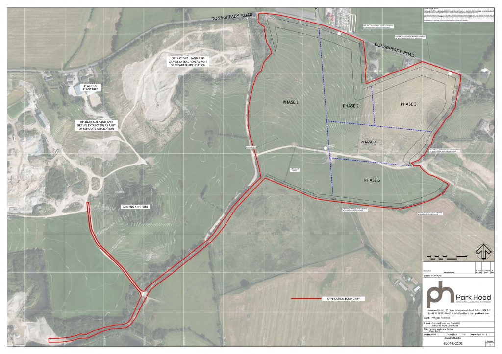
This proposal is described as:
“Proposed sand and gravel extraction, with progressive restoration involving inert backfilling, with internal haul road connections to the existing sand & gravel quarry at 37 Moyagh Road and access via P Woods & Sons at 38A Moyagh Road, Strabane, and associated landscaping and other site works.”
The project involves the extraction of approximately 1.5-1.8 million cubic metres of sand and gravel, which will take place over approximately over a 10-15 year period.
The extraction will occur in phases, at a rate of around 1.5 hectares per year, equating to an average daily rate of 700 tonnes. The Stages of the operation are listed below:
Proposed Development Activities:
1.SITE COMMISSIONING PHASE:
- Creation of a landscaped berm along the northern boundary to buffer visual and noise impacts.
- Tree planting along the southern boundary.
- Installation of settlement ponds to manage surface water runoff and minimize sediment risk.
- OPERATIONAL PHASE:
- Phased extraction from west to east and south to north, with progressive restoration.
- Mechanical excavation to remove the sand and gravel
- Retaining a shoulder of the slope in the south until final phases to limit visual impacts.
- Dust and noise management plans will be implemented.
- Surface water management through settlement ponds.
- Use of internal haul roads to minimize additional traffic on public roads.
- RESTORATION AND SITE DECOMMISSIONING PHASE:
- Part of the void will be backfilled with recycled and / or clean inert waste soils and gravel to create a gentle gradient.
- Land will be regraded and vegetated to a form suitable for agricultural use.
- Retention of landscaping and planting to enhance biodiversity.
Proposed Plans
The following images include the proposed plans and these show the proposed layout and indicates where each of the new elements are to be located. 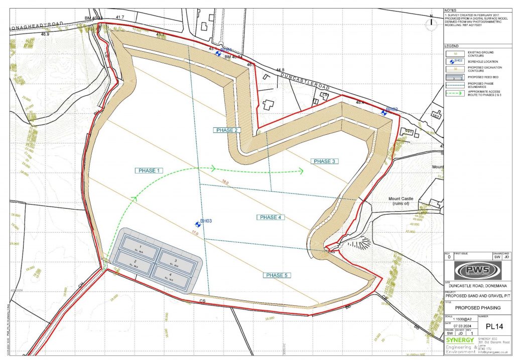
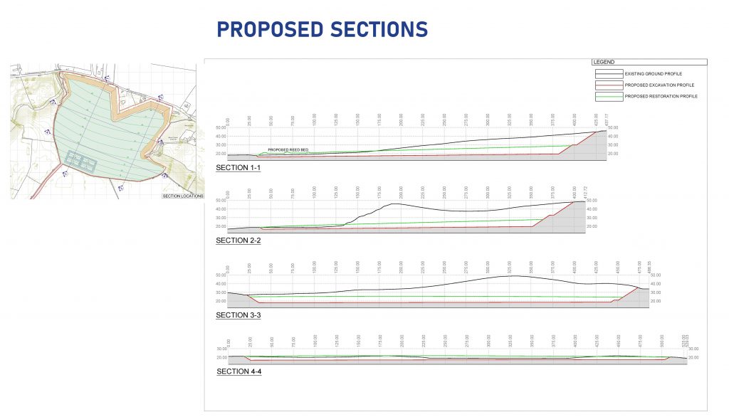
The proposal involves Progressive Restoration. This means that after each phase is extracted, it will be restored by backfilling with inert material, such as waste soils and stone or topsoil, while the operator moves on to extract the next phase. This is shown in the image below as it shows the phases of extraction and restoration, with the light colour representing the sandy coloured site during the extraction phases and the green colour shows the site returned to grassland.
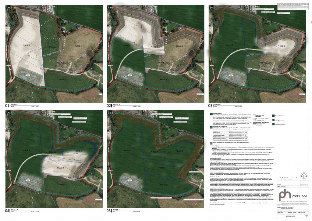
The following images also provides views of how the site will look during the operational phases.
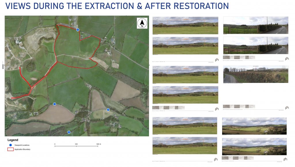
The final restoration of the site will restore the entire site back to grassland.
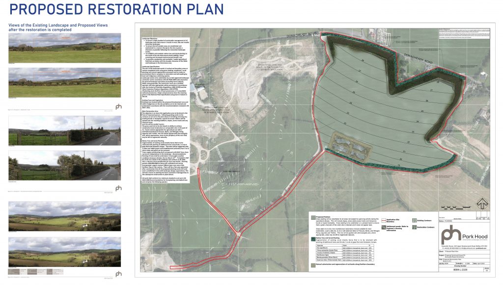
WHAT HAPPENS NEXT?
At the end of this consultation period the applicant, P Woods & Son, intends to submit a planning application to Derry City & Strabane District Council. In the meantime, we are keen to hear the views of the local community and are carrying out this consultation to help inform the design process prior to submission of the planning application later this year.
Feedback From
